REMOTE SENSING, GIS, GPS AND THEIR USE IN ENVIRONMENTAL MANAGEMENT
Sukanya Baruah
Department of Life Sciences, Dibrugarh University, Dibrugarh, Assam, India
Parijat path, Khania Gaon, P.O.C.R. Building, Dibrugarh, Assam, India 786003,
email id: sukanyabaruah.sb@gmail.com, Contact No.: 7002067122
Introduction
The representation of spatial data on maps has become an increasingly valuable instrument in environmental management. Data analysis techniques have evolved from descriptive to perspective maps which led to an increased role of computers in map making. This display of spatial data on a visual information platform is known as Geographical Information system (GIS).
Increasing environmental degradation has led to the growing concern for developing new analytic tools to identify, observe and solve the environmental concerns. These tools include Remote sensing, GIS (Geographic Information System) and GPS (Global Positioning System).
- Remote sensing
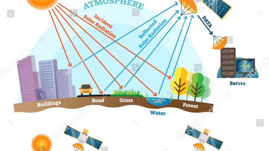
Remote sensing is defined as obtaining information about an object or objects by observing them from a distance and without having actual contact with them. It is the technique of observing the Earth’s surface from the space by satellites. The data is collected by sensors attached to the aircraft or the satellite that detects the energy reflected from the Earth. Remote sensors are of two types:
- Passive remote sensing: The naturally reflected energy from the object or earth’s surface is measured by sensors.
- Active remote sensing: The system supplies its own source of energy to illuminate the objects and measure the energy returned to the system.
A common example is the use of a laser-beam remote sensing system, where data is collected by projecting a laser to the Earth’s surface and measuring the time it takes for it to be reflected back to the sensor.
Stages of remote sensing:
- Source of electromagnetic energy (solar / self emission).
- Energy transmission from sun to the Earth’s surface, and absorption; scattering during passage of solar radiation through Earth’s atmosphere.
- Interaction of electromagnetic radiation with Earth surface such as reflection, scattering, absorption and re-emission.
- Transmission of reflected, scattered, emitted energy from the object.
- Sensor data output.
Components of the satellite system:
- Space segment: The satellite contains the sensor system which is put into the orbit. The sensor system consists of a pre-planned format and transmits information to the Earth receiving stations. The data obtained in digital form can be converted to the picture format by electro-optical processing.
- Sensor system: These are instruments that sense the objects on Earth’s surface and record the data.
- Ground segments: The solar energy containing all the regions of the electromagnetic spectrum falls on the Earth and gets partially absorbed and partially reflected. The reflected part is generally used in remote sensing. The ground system controls the movements and tracks the satellite paths.
- Geographical Information System (GIS)
It is a computer-based tool that analyzes stores, manipulates and visualizes geographic information, usually in a map. It uses data from satellites and by remote capturing using high resolution cameras by aircrafts. All types of data are stored in different layers in the graphic form. In GIS, the emphasis is on retrieval, analysis and decision support and generation of new information.
The four main ideas of Geographic Information Systems (GIS) are:
- To create geographic data.
- Manage it in a database.
- Analyze and find patterns.
- Visualize it on a map.
Components of GIS:
- Data: The two main types of GIS data are raster and vector. Raster looks like grid because they store data in rows and columns. Vectors are points, lines and polygons with vertices.
- Hardware: It includes mobile phones, powerful servers or a personal GIS workstation.
- Software: GIS software specializes in spatial analysis by using math in map. It blends geography with modern technology to measure, quantify and understand our world.
- Global Positioning System (GPS)
GPS is a satellite navigation system used to determine the ground position of an object. It consists of three segments- Space segment, control segment and ground segment.
Space segment: It consists of 24 active satellites that transmit one-way signals, which can be received by a GPS receiver on Earth and then analyzed to determine its precise location.
Control segment: It consists of a worldwide monitor and control stations that maintain the satellites in proper orbits and adjust the satellite clocks.
User segment: It consists of the GPS receiver equipment, which receives the signals from the GPS satellites and uses the transmitted information to calculate the user’s position and time.
USES OF REMOTE SENSING, GIS AND GPS IN ENVIRONMENTAL MANAGEMENT:
- REMOTE SENSING:
- Determining soil moisture content: A significant area of research that is currently taking place in the remote sensing field is NASA’s Soil Moisture Active Passive (SMAP) Mission. Earth observation satellites are used to retrieve data every 2-3 days that measure soil moisture in the top 5 cm of soil over the Earth’s surface. Due to its extensive use in agriculture and supporting vegetation growth, it is important to maximize the knowledge of the Earth’s top soil.
- Agriculture: Satellite and airborne images are used as mapping tools to classify crops, examine their health, examine their viability, and monitor farming practices. Agricultural applications of remote sensing include crop type classification, crop condition assessment, crop yield estimation, mapping of soil characteristics, mapping of soil management practices, and compliance monitoring (farming practices).
- Forestry: Forestry applications of remote sensing includes the following:
- Reconnaissance mapping: Objectives to be met by national environment agencies include forest cover updating, depletion monitoring, and measuring biophysical properties of forest stands.
- Commercial forestry: These include collecting harvest information, updating inventory information for timber supply, broad forest type, vegetation density, and biomass measurements.
- Environmental monitoring: Conservation authorities are concerned with monitoring the quantity, health, and diversity of the earth’s forests.
- Geology: These include bedrock mapping, lithological mapping, sand and gravel exploration, mineral exploration, hydrocarbon exploration, environmental geology, geo-hazard mapping and planetary mapping.
- Hydrology: Hydrological applications include wetlands monitoring, soil moisture estimation, snow pack monitoring, measuring snow thickness, determining the snow water equivalent, ice monitoring, flood monitoring, river/delta change detection, drainage basin mapping, watershed modeling and irrigation .
- Land Cover and land use: Land cover refers to the surface cover on the ground, while land use refers to the purpose the land serves. Land use applications include natural resource management, wildlife habitat protection, baseline mapping for GIS input, urban expansion, logistics planning for seismic/exploration/resource extraction activities, damage delineation (tornadoes, flooding, volcanic, seismic, fire), legal boundaries for tax/property evaluation, target detection, and identification of landing strips, roads, clearings, bridges, and land/water interface.
- Mapping: It includes the following:
- Remote sensing provides a means of identifying planimetric data in an efficient manner; so imagery is available in varying scales to meet the requirements of many different users.
- A variety of sensors and methodologies to generate Digital elevation models (DEMs) from remotely sensed data are available for mapping applications.
- Oceans and coastal monitoring: These include ocean pattern identification, storm forecasting, fish stock and marine mammal assessment, oil spills, and navigation routing.
- GIS:
- Environmental Impact Analysis (EIA): EIA is an important policy initiative to conserve natural resources and environment. The EIA can be carried out efficiently with the help of GIS, by integrating various GIS layers, assessment of natural features can be performed.
- Disaster Management: GIS helps risk management and analysis by displaying which areas are likely to be prone to natural or man-made disasters. When such disasters are identified, preventive measures can be developed.
- Landslide hazard: Landslide hazard zonation is the process of ranking different parts of an area according to the degrees of actual or potential hazard from landslides. GIS helps to efficiently collect, manipulate and integrate a variety of spatial data such as geological, structural, surface cover and slope characteristics of an area, which can be used for hazard zonation.
- Determination of land cover and land use: The role of GIS technology in land use and land cover applications is that we can determine land use/land cover changes in different areas. It can also detect and estimate the changes in the land use/ land cover pattern within time. It enables us to find out sudden changes in land use and land cover either by natural forces or by other activities like deforestation.
- Estimation of flood damage: GIS helps to map flooding risk areas for evaluating the flood potential level in surrounding area. It helps to document the need for federal disaster relief funds.
- Management of natural resources: GIS technology helps to maintain and manage the agricultural, water and forest resources. GIS is used to analyze geographic distribution of water resources. They are interrelated, e. forest cover reduces the storm water runoff and tree canopy stores approximately 215,000 tons carbon. GIS is also used in afforestation.
- Soil Mapping: Soil mapping provides resource information about an area. GIS Helps to identify soil types in an area and to depict soil boundaries. It is used for identification and classification of soil. Soil map is widely used by the farmers in developed countries to retain soil nutrients and earn maximum yield.
- Wetland Mapping: GIS helps to design projects for wetland conservation and provides options for wetland mapping. Integration with Remote Sensing data helps to complete wetland mapping on various scale.
- Identification of volcanic hazard: Potential volcanic hazard zone can be recognized by the characteristic historical records of volcanic activities. It can be incorporated with GIS. Thus, an impact assessment study on volcanic hazards deals with economic loss and loss of lives and property in densely populated areas.
- GPS:
- Evaluates an area’s wildlife: GPS technology is essential in strategic planning as well as the conservation efforts of the forests. Coordinates provided by the GPS are incorporated with imagery hence making wildlife evaluation in most of the impenetrable forests possible.
- Management of logging in forests: GPS is used to collect information including mapping which helps different users to manage the rate of deforestation.
- Mapping the perimeter of forest fires: GPS technology is attached to helicopters which help the firefighter personnel to easily locate the forest fires. Besides the fire Personnel used the GPS to easily locate important resources like the cabins and bridges and put the fires off to protect people and other things from destruction.
- Tracking oil spills: GPS installed in buoys helps in the tracing of oil spills movements. Majorly this technology has been used to help clean up crews to trace and respond to oil spills. Oil spills are dangerous to marine life, people as well as the environment.
- Predicting earthquakes: GPS technology provides scientists with the exact position information which helps them understand the timeline of the earthquakes and hence device protective measures against them to most of the earthquake-prone areas. Scientists through the help of the GPS study how earthquakes occur in time and also they get to predict the next time one would occur and a precise location.
- Crustal and seismic monitoring: Actual and precise positioning information provided for by GPS technology enables scientists to monitor the occurrence of any crustal and seismic activities.
- Analysis of environmental concerns: Information provided by GPS, which also has GIS packages, proves to be essential as they provide comprehensive data related to the environment. These environmental concerns may range from forest fires, oil spills to population extinction among others.
- Environmental Resources: GIS helps in mapping the aerial extent of wetlands and wildlife habitats, determining the location and areal extent of forest stands, mapping and locating cultural resource sites, mapping and characterizing chemically-stressed areas.
- Hydrogeology: It helps in mapping the extent and flow path of ground and surface water contamination, determining the elevation of groundwater monitoring wells, mapping boundaries of fluvial channels for erosion studies and assessing acreages of fire damage.
- Weather forecast: By integrating GPS measurements into operational methods used by meteorologists, the atmosphere’s water content can be determined, improving the accuracy of weather forecasts.
- Preserving endangered species: The migratory patterns of endangered species, such as the mountain gorillas of Rwanda, are tracked and mapped using GPS, helping to preserve and enhance declining populations.
Conclusion:
Remote sensing, GPS and GIS have proven to be important tools in managing the environment. Satellite data helps to depict the various changes of the earth surface. These tools have progressively improved applications in various fields such as environment management, resource planning, urban-regional planning, utilities planning, health planning and geomorphology. Integrated application of GIS-GPS-Remote sensing technologies is used in precision farming and site-specific crop management. Precision farming techniques are employed to increase yield, reduce production costs, and minimize negative impacts to the environment. Recent advancements in the fields of RS, GIS, GPS, and higher level of computation will help in providing and handling a range of data simultaneously in a time and cost-efficient manner and thus combating the problems related to the environment.
References:
- UK Essays. (November 2018). Applications Of Remote Sensing Environmental Sciences Essay. Retrieved from https://www.ukessays.com/essays/environmental-sciences/applications-of-remote-sensing-environmental-sciences-essay.php?vref=1
- 10 Importances of GIS in Environment [GrindGIS]. Retrieved from https://grindgis.com/blog/10-importance-of-gis-in-environment#:~:text=GIS%20stands%20for%20Geographic%20Information,informed%20and%20smooth%20decision%20making.
- S. Government, GPS: The Global Positioning System (2017). http://www.gps.gov. Accessed Sept. 2020.
 Nanoparticles as oral vaccine delivery system")

